
The Manasquan River Inlet Study
Did you know…
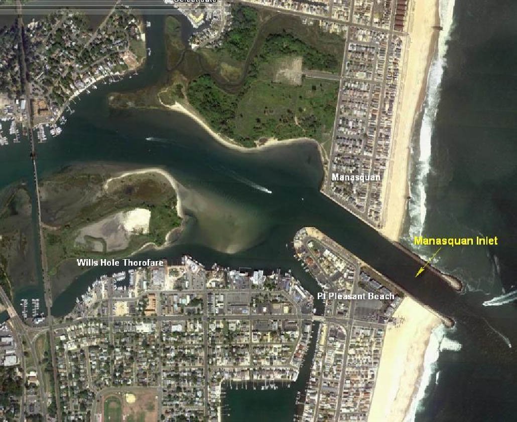
The Manasquan River Inlet is located 22 miles southward of the Sandy Hook Historic Lighthouse. The inlet is the Atlantic entrance to the Manasquan River and the northern terminus of the New Jersey Intracoastal Waterway.
The Manasquan River is approximately 81 miles long and drains an area of 81 square miles into the Atlantic Ocean through the Manasquan Inlet. This river also connects to Barnegat Bay via the Point Pleasant Canal.
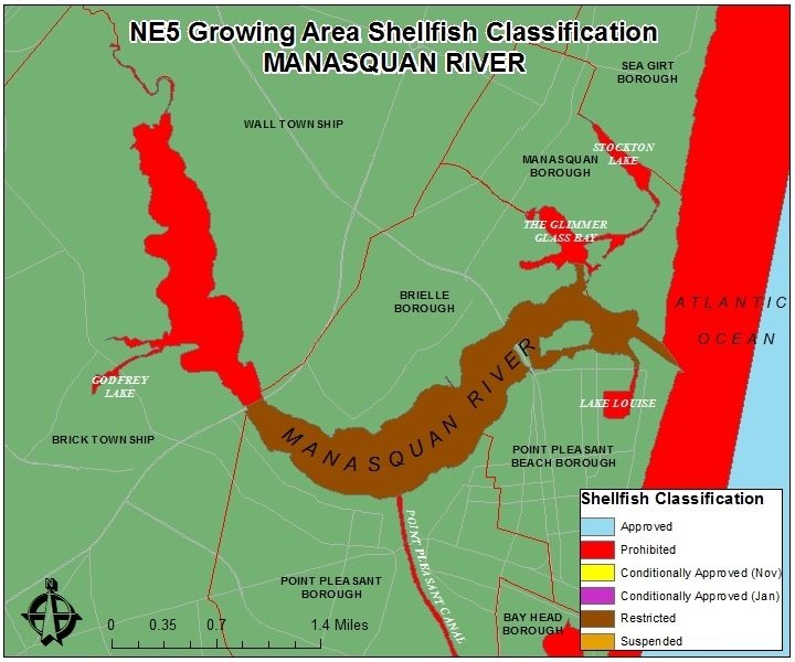
There are several small lakes off of the Manasquan River including Lake Louise, Stockton Lake, The Glimmer Glass Bay, and Godfrey Lake.
Six Municipalities surround the Manasquan River, including Brick Township, Wall Township, Point Pleasant Borough, Point Pleasant Beach Borough, Manasquan Borough, and Brielle Borough.
The river’s name, “Manasquan,” comes from the Native Lenape People. The word manasquan or something similar in the Lenape language most likely means a "Place to Gather Grass or Reeds." People often refer to the town as "Squan" and there are many historical references to the Squan River. Other towns in or near the Jersey Shore that have Lenape names are Mantoloking and Manahawkin.
Shellfish Harvesting
According to New Jersey Department of Environmental Protection: Shellfish Classification for this growing human populated area includes Restricted (55%) and Prohibited (45%) classifications. There are no Approved waters in this growing area. Waters are Prohibited upstream of the Rt. 70 Bridge across the Manasquan River, and Restricted downstream of the Rt. 70 Bridge. Additionally, the Point Pleasant Canal, Lake Louise, The Glimmer Glass Bay, and Stockton Lake are Prohibited areas. The Restrictedclassification means that it is prohibited to harvest shellfish from these waters to direct market; a special permit must be issued to be in compliance with N.J.A.C. 7:12.
History (according to Wikipedia)
The present day location of the Manasquan River Inlet is several thousand yards south of its original location. The original inlet had been near the former Manasquan Coast Guard Station, which was adjacent to Stockton Lake.
The Manasquan inlet historically had always been shallow and a navigational hazard, which made it difficult for large boats to maneuver. When the Point Pleasant Canal was dug in 1926, the Manasquan River's water rapidly flowed through the man-made opening disrupting the natural flow of the river, and this caused the inlet to completely close with sand for several years. The inlet's closure was so complete that it was possible to walk from Manasquan to Point Pleasant beach on dry ground.

From 1926 to 1931 several efforts were made to reopen the inlet, including the use of high pressure water by the National Guard and local firemen to erode a narrow channel through the sand. These efforts failed to keep the channel open and the inlet remained closed. In 1930 work began to reopen the inlet. The Army Corps of Engineers put up temporary piers and began building jetties. The jetties were constructed with rock excavation from the Second Avenue Subway in Manhattan. The project cost $600,000 with funds from local, state and federal government. The inlet was officially reopened on August 29, 1931, with a parade of boats and was attended by New Jersey Governor Morgan F. Larson.
MORE INFORMATION